Marine Spatial Planning

What is the purpose of the Marine Spatial Planning DeST?

The Marine Spatial Planning (MSP) Decision Support Tool (DeST) provides consolidated view of data sources that can inform MSP and the development of Marine Area Plans (MAPs). 

While each DeST has a dedicated lead, responsible for creating the respective Technical Advisory Groups (TAGs), the Marine Spatial Planning DeST does not as it is guided by instructions obtained from the MSP National working Group. Please feel free to contact us for more information.

Mobirise Website Builder

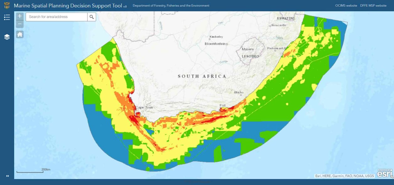
MSP DeST screenshot (Image: DFFE, 2022)

Why?

By developing a MSP DeST, DFFE will be able to fulfil its legislative mandate and governance requirements outlined in the MSP Act (2018) and MSP Framework (2017) in line with national objectives of economic growth and sustainable development as outlined in the National Development Plan (NDP).

The data represented in the MSP Support Viewer DeST is not exhaustive. The aim of publishing the content of the viewer on an open internet platform is to ensure transparency to the data sources that are being considered for MSP and MAPs, and to facilitate additional contributions from authoritative data sources.

Contributors

  1. National Government Departments
    Department of Forestry, Fisheries and the Environment, Department of Agriculture, Land Reform and Rural Development, Department of Mineral Resources and Energy, Department of Transport, Department of Monitoring and Evaluation,  Department of Public Works, Department of Sports, Arts and Culture, Department of Science and Innovation, Department of Tourism
  2. Government Entities
    Council for Geoscience, South African Navy Hydrographic Office, Petroleum Agency of South Africa, South African Environmental Observation, Network, South African Heritage Resources Agency, South African Maritime Safety Authority, South African National Biodiversity Institute, South African National Parks, Transnet National Port Authority
  3. Other organisations
    GIZ, Nelson Mandela University

Frequently asked questions

  • Can I download the data?
    No. The DFFE has entered into strict data agreements with relevant custodians and any means of data dissemination is not allowed in terms of these agreements. For access to any of the data, you would have to contact each data custodian individually. Data for which the DFFE is the custodian can be downloaded via the Department's EGIS website.
  • How is the data managed?
    The data is managed in accordance with the provisions of the Spatial Data Infrastructure Act (Act. 54 of 2003) and any further provisions provided by the data custodians.
  • How often is the data updated?
    Data is updated as and when instruction is provided by the established National Working Group.
Mobirise Website Builder

© Copyright 2024 DFFE. All Rights Reserved.

Website Builder Software