Data Capture Apps

What is the purpose of the Data Capture Apps?

The data capture apps represents the OCIMS technology response in support of various initiatives where data is being captured on a routine basis. The apps allow for data standards to be implemented so that data is ready to use once it has been submitted to the DFFE's cloud-hosted geodatabase.

Some of the data capture apps are restricted to certain users, but others are open to anyone wanting to participate in the various initiatives. Where relevant, the data capture via these apps feed to the appropriate DeST.

Please feel free to contact us if you are interested in joining one of the related Technical Advisory Group (TAG) or if you have any suggestions for improvement.

Benefits

Mobile friendly 

The apps are compatible with multiple devices and operating systems (Windows, IOS, Android).

Data is safe

The data cannot be edited once submitted and data cannot be accessed via the apps. Data can only be submitted.

Offline mode

Offline mode is when you do not have access to data/Wi-Fi. Data is stored locally on your device and you can submit once data/Wi-Fi is available (online mode). 

Mobirise Website Builder

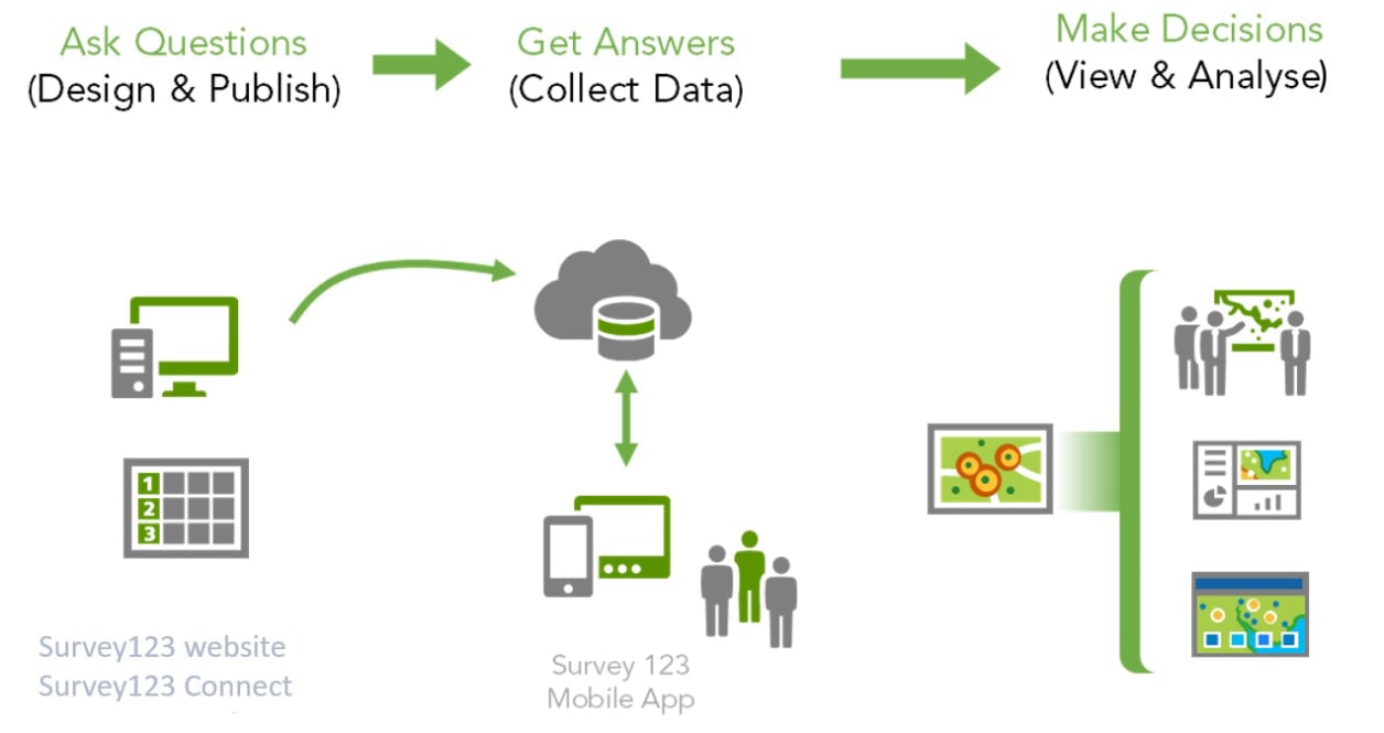
How the Survey123 app works (Source: ESRI)

How the apps work

We use the ESRI suite of software for our apps, specifically Survey123 for ArcGIS. The OCIMS team will engage with the client to construct a survey form, which will be the data capture user interface. The users will either download the Survey123 app onto their device(s) or make use of the web-based version. Once the data is submitted, it will be sent to the cloud-hosted geodatabase. The standardisation implemented means that the data is ready for use, analysis and visualisation. 

Open apps & data visualisation

These apps are open to anyone who would like to contribute
Mobirise Website Builder
Water Quality Sampling Data Capture App

The app allows users to record the results of point source water sampling in estuaries and beaches.

Mobirise Website Builder
Water Quality Sampling Dashboard

The dashboard provides visualisation of the data captured via the data capture tool

Mobirise Website Builder
Avian Influenza Reporting Dashboard

The dashboard provides visualisation of the data captured via the data capture tool

Closed apps

These apps are only available to approved stakeholders
Mobirise Website Builder
Marine Animal Sightings

Counts of marine animal sightings are submitted by permitted operators for long term monitoring purposes.

Mobirise Website Builder
Phytoplankton Counts

Phytoplankton counts undertaken by aquaculture stakeholders are recorded for long term monitoring purposes.

Frequently asked questions

  • Where can I download the Survey123 app?
    You can download Survey123 from your device's app store.
  • Do I need login credentials?
    Some forms require user credentials but open forms do not. To access open forms, simply click on the link and follow the prompts.
  • Who owns the data submitted via the apps?
    The OCIMS client is the data owner and provides the OCIMS team with the terms of use and permissions needed to effectively manage and store the data.
  • Can data be downloaded?
    If the data owner permits it, data can be made available for download. Often data is archived in MIMS and can be accessed from there.
Mobirise Website Builder

© Copyright 2024 DFFE. All Rights Reserved.

Drag and Drop Website Builder